


AMINI LIGHTHOUSE
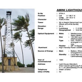
The Amini Island is at a distance of 407 km (220 nautical miles) from Kochi and located between Kavaratti Island in the south and Kadmat Island in the north. This island has an oval shape with a width of 1.20 km at the broadest point and a length of 2.70 km. It lies between 11o 06′ and 11o 08′ N latitude and 72o 42′ and 72o 45′ E longitude, having a land area of 2.60 sq km and lagoon area of 1.50 sqkm.This oval shaped island is 2-3 m above the mean sea level, with a depression at the centre. 30m height G I trestle tower was commissioned in 1984, due to poor condition another G I trestle tower with same height was constructed near to old tower in 2018 and the light equipment was shifted to new tower.
Master Ledger of AMINI LIGHTHOUSE(817.84 KB)

