


Manapad Point Lighthouse
This Lighthouse is situated on hillock unlike other Lighthouses. This Manapad village is a historical place; believe that the Lord “Muruga” defeated the ratchasa named “Sooran” in olden days. This place was called as “Maapadugai” means that ratchasa fell down. Later the name was flourished as Manapad. The Lighthouse was established in 1888 (134 year) by British government. The place was identified as salt export zone, for the purpose the British people stayed here, they constructed the quarters later they constructed the Lighthouse.
The first Lighthouse light was illuminated with Gas from 1888 to 1900 then it is converted into P.V and worked till the year of 1994, then it is again modified with the electric bulb and working till date. At presently CDMT 150w 3no’s of cluster is in service. The station is accompanied with static sensor, on grid solar panel 25kwh, NAIS, Automation and Racon.
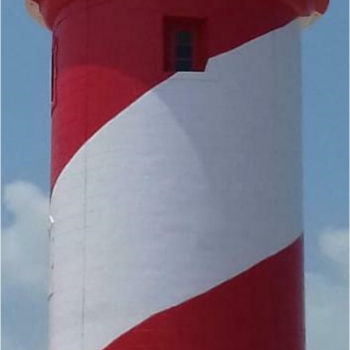
This Lighthouse area is 3.703 hector. The Lighthouse is a masonry tower 18 Mtr height with Red & white spiral bands (diagonal strips). The road exists up to lighthouse. The bus transportation is available till Manapad village there after we have to walk on the hillock around 2 km. The train facility is available up to “Thiruchendur” town, which is 18km away from Manapad and 58 Km from Toothukudi railway station.
Master Ledger of Manapad Point Lighthouse(316.97 KB)

