


EAST ISLAND LIGHTHOUSE AND DGPS STATION
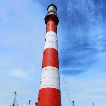
East Island Lighthouse has 37 Meter Cast Iron Tower established in the year 1969 and island marks the northern end of the Andaman Islands. This Lighthouse station is equipped with Major marine aids to Navigation like DGPS, NAIS, RACON and STATIC SENSOR for the safe navigation of both national and the international seaborne merchant traffic through the exclusive economic zone of the country. This lighthouse station belongs to the North and Middle Andaman administrative district, part of the Indian union territory of Andaman and Nicobar Islands. East Island has a coastline of 10.60 km and is lying 220 km north from Port Blair. Local connectivity by road or waterways (ships) is available upto Aerial bay (10 Km from Diglipur) and from aerial bay, the east island could be reached through private boat/mechanized dinghy. A mechanized dinghy services is provided at station for collection of ration and essential services from Aerial Bay to East Island Lighthouse on weekly basis or as and when required. The nearest Post office, Dispensary, High School, Police Station are available at Diglipur. Nearest port is at Aerial Bay, which is about 30 Nm from East Island. The Police look out post having a HF R/T link (with Port Blair) and a police compound is situated adjoining to Lighthouse campus, the Island is otherwise uninhabited.
Master Ledger of EAST ISLAND LIGHTHOUSE AND DGPS STATION(289.06 KB)

