


NAIS
National Automatic Identification System - NAIS
Automatic Identification System (AIS) is a ship and shore based data broadcast system in accordance with SOLAS Chapter V (Regulation 19) resolution MSC.74 (69) – May 1998, operating in the VHF maritime band. Its characteristics and capability make it a powerful tool for enhancing situational awareness, thereby contributing to the safety of navigation and efficiency of shipping traffic management.
Overview of NAIS Network
In an NAIS Network, real time AIS data is typically routed to multiple clients who wish to be a part of the AIS data service. Typically these clients are Port Authorities, Regulators, VTS Centres, Civil Defence, National Defence, Lighthouse, Customs and/or offshore authorities. These various authorities may already have tracking and surveillance systems to which the AIS data is sent or may require a situational awareness display. Most AIS networks have a data repository (database) for logging AIS data for replaying any incident and for performing statistical analysis of vessel traffic. The NAIS network has been established in entire main coastal area along with Andman & Nicobar and Lakshadweep Islands in two phases.
- Phase I: 74 AIS shore stations to cover the main land.
- Phase II: 07 AIS shore stations to cover A&N and 6 Lakshadweep Islands.
The Director General Lighthouses and Lightships (DGLL) established the National AIS Network, by setting up 87 shore stations on existing lighthouses along our coast for facilitating Aids to Marine Navigation and tracking of SOLAS Vessels. The network is planned to track all the SOLAS compatible vessels and also those carrying transponders as per DG Shipping notices so as to have an overall image of AIS complying vessels along the Indian Coastline which apart from management aids to navigation and enhancing value addition in regulatory roles of DG Shipping will greatly enhance the maritime domain awareness along our coastline and thereby add to coastal security.
The National AIS (NAIS) network comprises of following:-
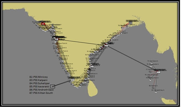
- 87 Physical Shore Stations (PSS) installed at various light houses on the Indian Coast.
Eight Regional Control Centre (RCC) located at Regional Headquarters
- Jamnagar, Mumbai, Kochi, Chennai, Kolkata, Vishakhapatnam, Kavarati and PortBlair.
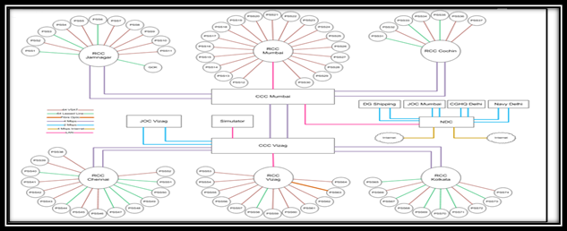
- Two Coastal Control Centers (CCC) located at Deep Bhavan, Mumbai
- Dolphin’s Nose Light House Vishakhapatnam.

- One National Data Centre(NDC) located at Deep Bhavan Mumbai
- One simulator located at Dolphin’s Nose Light House Vishakhapatnam.

- Viewing terminals are shared with national coastal and security agencies #BBD0E0 »
Indian Navy at IHQ MoD(N)
Indian Coast Guard located at CGHQ New Delhi.
DG Shipping located at LRIT Data Centre Jahaz Bhavan Mumbai.
IMAC Gurgaon
Joint Operations Centres(JOC) at Mumbai, Cochin, Vishakhapatnam and PortBlair.
NTRO New Delhi
DGLL Noida
Importance of NAIS in Indian perspective
- National AIS Network Is a benchmark project in terms of nationwide maritime information gathering effort;
- Being extended for tracking small vessels;
- Is so designed to allow integration of information from other coastal surveillance sensors;
- The AIS Network data when fused with radar data would provide a complete picture. The static radar project would only provide tracking of targets and not identification;
- The capability of network is being explored for broadcast of weather warning & safety messages (Navtex Messages)
National Automatic Identification System (NAIS) LIST OF PHYSICAL SHORE STATIONS
| Sl No | ALOL No | Site Name | Lat N / Long E | MMSI NO | LL/VSAT | RCC | Total Sites Per RCC |
|---|---|---|---|---|---|---|---|
| 1 | 0396 | PSS Dwarka | 22° 14.2’ N 68° 57.5’ E |
004192211 | Lease Line | Jamnagar | 11 |
| 2 | 0398 | PSS Navadra | 21° 56.5’ N 69° 13.9’ E |
004192212 | VSAT | Jamnagar | |
| 3 | 0400 | PSS Porbandar | 21° 37.3’ N 69° 37.2’ E |
004192213 | Lease Line | Jamnagar | |
| 4 | 0404 | PSS Navibander | 21° 27.0’N 69° 47.2’ E |
004192214 | VSAT | Jamnagar | |
| 5 | 0406 | PSS Mangrol | 21° 06.5 N 70° 06.3 E |
004192215 | VSAT | Jamnagar | |
| 6 | 0410 | PSS Veraval | 20° 54.6 N 70° 21.2 E |
004192216 | Lease Line | Jamnagar | |
| 7 | 0414 | PSS Diu Head | 20° 41.5 N 70° 49.7 E |
004192217 | VSAT | Jamnagar | |
| 8 | 0432 | PSS Jafarabad | 20° 51.4 N 71° 22.9 E |
004192218 | VSAT | Jamnagar | |
| 9 | 0438 | PSS Jegri Island | 21° 02.4 N 71° 48.2 E |
004190009 | VSAT | Jamnagar | |
| 10 | 0444 | PSS Gopnath | 21° 12.2 N 72° 06.6 E |
004192219 | VSAT | Jamnagar | |
| 11 | 0448 | PSS Piram Island | 21° 35.9 N 72° 21.2 E |
004192220 | VSAT | Jamnagar | |
| 12 | 0470 | PSS Luhara | 21° 39.5 N 72° 32.9 E |
004192221 | VSAT | Mumbai | 19 |
| 13 | 0476 | PSS Hazira | 21° 05.5 N 72° 38.6 E |
004192222 | VSAT | Mumbai | |
| 14 | 0479 | PSS Kanai Creek | 20° 48.7 N 72° 49.7 E |
004192223 | VSAT | Mumbai | |
| 15 | 0489 | PSS Umargam | 20° 11.7 N 72° 45.0 E |
004192224 | VSAT | Mumbai | |
| 16 | 0491.5 | PSS Tarapur | 19°50.7’ E 72°39.5’N |
004192225 | VSAT | Mumbai | |
| 17 | 0499 | PSS Utan | 19° 16.5 N 72° 46.8 E |
004192226 | VSAT | Mumbai | |
| 18 | 0558 | PSS Korlai Fort | 18° 32.3 N 72° 54.5 E |
004192227 | VSAT | Mumbai | |
| 19 | 0562 | PSS Nanwell | 18° 16.8 N 72° 56.3 E |
004192228 | VSAT | Mumbai | |
| 20 | 0566 | PSS Tolkeshwar | 17° 33.9 N 73° 08.5 E |
004192229 | VSAT | Mumbai | |
| 21 | 0580 | PSS Ratnagiri | 16° 59.2 N 73° 16.4 E |
004192230 | VSAT | Mumbai | |
| 22 | 0586 | PSS Wagapur | 16° 36.3 N 73° 19.3 E |
004192231 | VSAT | Mumbai | |
| 23 | 0590 | PSS Devgarh | 16° 23.3 N 73° 22.6 E |
004192232 | VSAT | Mumbai | |
| 24 | 0598 | PSS Vengurla | 15° 51.2 N 73° 37.0 E |
004192233 | VSAT | Mumbai | |
| 25 | 0606 | PSS Aguada | 15° 29.5 N 73° 46.4 E |
004192234 | VSAT | Mumbai | |
| 26 | 0634 | PSS Oyster Rocks | 14° 49.2 N 74° 03.7 E |
004192235 | VSAT | Mumbai | |
| 27 | 0644 | PSS Honavar | 14° 16.5 N 74° 26.6 E |
004192236 | VSAT | Mumbai | |
| 28 | 0648 | PSS Bhatkal | 13° 57.0 N 74° 32.0 E |
004192237 | VSAT | Mumbai | |
| 29 | 0658 | PSS Kaup | 13° 13.4’ N 74° 44.2’ E |
004192238 | VSAT | Mumbai | |
| 30 | 0660 | PSS Suratkal | 13° 00.2 N 74° 47.4 E |
004192239 | VSAT | Mumbai | |
| 31 | 0668.5 | PSS Kasargod | 12° 30.3 N 74° 58.5’ E |
004192240 | Lease Line | Cochin | 07 |
| 32 | 0682 | PSS Kudalur | 11° 28.0 N 75° 38.3 E |
004190033 | Lease Line | Cochin | |
| 33 | 0669.5 | PSS Mount Dilli | 12° 00.4 N 75° 12.2 E |
004192241 | VSAT | Cochin | |
| 34 | 0689 | PSS Beypore | 11° 09.4 N 75° 48.4 E |
004192242 | VSAT | Cochin | |
| 35 | 0692 | PSS Ponnani | 10° 46.5 N 75° 55.3 E |
004192243 | Lease Line | Cochin | |
| 36 | 0698 | PSS Kochi (Vypin) | 09°59.8 N 76° 13.8 E |
004192244 | VSAT | Cochin | |
| 37 | 0706 | PSS Alleppey | 09° 29.5 N 76° 19.3 E |
004192245 | VSAT | Channai | |
| 38 | 0712 | PSS Tangasseri | 08° 52.7 N 76° 34.0 E |
004192246 | VSAT | Chennai | 15 |
| 39 | 0718 | PSS Vilinjam | 08° 22.9 N 76° 58.8 E |
004192247 | VSAT | Chennai | |
| 40 | 0726 | PSS Cape Comorin | 08° 04.8 N 77° 32.8 E |
004192248 | Lease Line | Chennai | |
| 41 | 0730 | PSS Manappad | 08° 22.3 N 78° 03.9 E |
004194415 | VSAT | Chennai | |
| 42 | 0734 | PSS Pandiyan Tivu. | 08° 47.1 N 78° 11.9 E |
004194416 | VSAT | Chennai | |
| 43 | 0738 | PSS Kilakkarai | 09° 13.5 N 78° 47.0 E |
004194417 | VSAT | Chennai | |
| 44 | 0900 | PSS Pamban Island | 09° 17.2 N 79° 13.3 E |
004194418 | Lease Line | Chennai | |
| 45 | 0901.2 | PSS Ammapatinam | 10° 00.6 N 79° 13.7 E |
004194419 | VSAT | Chennai | |
| 46 | 0902 | PSS Kodikkarai | 10° 16.7 N 79° 49.6 E |
004194420 | VSAT | Chennai | |
| 47 | 0914 | PSS Nagapattinam | 10° 45.9 N 79° 51.1 E |
004194421 | Lease Line | Chennai | |
| 48 | 0919 | PSS Porto Novo | 11° 30.2 N 79° 46.2 E |
004194422 | Lease Line | Chennai | |
| 49 | 0926 | PSS Pondicherry | 11° 54.9 N 79° 49.9 E |
004194423 | Lease Line | Chennai | |
| 50 | 0932 | PSS Mahabalipuram | 12° 36.8 N 80° 11.5 E |
004194424 | Lease Line | Chennai | |
| 51 | 0936 | PSS Madras | 13° 02.3 N 80° 16.8 E |
004194425 | Lease Line | Chennai | |
| 52 | 0950 | PSS Pulicat | 13° 25.2 N 80° 19.7 E |
004194426 | VSAT | Chennai | |
| 53 | 0951 | PSS Armagon | 13° 53.5 N 80° 12.3 E |
004194427 | VSAT | Vizag | 12 |
| 54 | 0952 | PSS Krishnapatnam | 14° 15.2 N 80° 07.7 E |
004194428 | VSAT | Vizag | |
| 55 | 0952.9 | PSS Vodarevu | 15° 48 0 N 80° 25.0 E |
004194429 | VSAT | Vizag | |
| 56 | 0952.5 | PSS Ramaypatnam | 15° 02.7 N 80° 03.0 E |
004194430 | VSAT | Vizag | |
| 57 | 0953 | PSS Nagayalanka | 15° 47.2 N 80° 59.2 E |
004194431 | VSAT | Vizag | |
| 58 | 0955 | PSS Machilipatnam | 16° 14.8 N 81° 14.0 E |
004194432 | Lease Line | Vizag | |
| 59 | 0957 | PSS Antervedi | 16° 19.0 N 81° 43.6 E |
004194433 | VSAT | Vizag | |
| 60 | 0958 | PSS Sacramento | 16° 35.2 N 82° 16.8 E |
004194434 | VSAT | Vizag | |
| 61 | 0964 | PSS Vakalapudi | 17° 00.8 N 82° 17.1 E |
004194435 | VSAT | Vizag | |
| 62 | 0966 | PSS Pentakota | 17° 18.0 N 82° 37.0 E |
004194436 | VSAT | Vizag | |
| 63 | 0970 | PSS Dolphin’s Nose | 17° 40.5 N 83° 17.7’ E |
004194437 | DGLL OFC | Vizag | |
| 64 | 0980 | PSS Santapile | 18° 03.9 N 83° 38.4 E |
004194438 | VSAT | Vizag | |
| 65 | 0982 | PSS Kalingapatnam | 18° 20.4 N 84° 07.6 E |
004194439 | Lease Line | Kolkata | 10 |
| 66 | 0986 | PSS Baruva | 18° 52.8 N 84° 35.8 E |
004194440 | VSAT | Kolkata | |
| 67 | 0988 | PSS Gopalpur | 19° 15.3 N 84° 54.5 E |
004194441 | Lease Line | Kolkata | |
| 68 | PSS Prayagi* | 19° 28.0 N 85° 10.0 E |
004190068 | VSAT | Kolkata | ||
| 69 | 1002 | PSS Puri | 19° 47.7 N 85° 49.8 E |
004194442 | Lease Line | Kolkata | |
| 70 | 1003 | PSS Chandrabhaga | 19° 52.1 N 86° 06.6 E |
004194443 | Lease Line | Kolkata | |
| 71 | 1004.4 | PSS Paradip | 20° 15.3 N 86° 39.5 E |
004194444 | Lease Line | Kolkata | |
| 72 | - | PSS Maipura | 004194445 | VSAT | Kolkata | ||
| 73 | - | PSS Balasore | 21° 29.18 N 86° 55.01 E |
004194447 | Lease Line | Kolkata | |
| 74 | 1028 | PSS Sagar Island | 21° 39.4 N 88° 02.9 E |
004194446 | VSAT | Kolkata | |
| 75 | 1201 | PSS East Island | 13° 37.79 N 93°02.94E |
004198001 | VSAT | Port Blair | 07 |
| 76 | - | PSS Mayabunder | 004198002 | VSAT | Port Blair | ||
| 77 | 1205 | PSS North Point | 11° 42.28 N 92° 45.29E |
004198003 | VSAT | Port Blair | |
| 78 | 1214 | PSS Little Andaman | 10° 30.93 N 92° 30.05E |
004198004 | VSAT | Port Blair | |
| 79 | 1220 | PSS Keating Point | 09° 15.48 N 92° 46.30E |
004198005 | VSAT | Port Blair | |
| 80 | 1223 | PSS Katchal | 21° 39.4 N 88° 02.9 E |
004198006 | VSAT | Port Blair | |
| 81 | - | PSS Campbell Bay | 004198007 | VSAT | Port Blair | ||
| 82 | 0758 | PSS Minicoy | 08° 16.0 N 73° 01.6 E |
004198008 | VSAT | Kavaratti | 06 |
| 83 | 0757 | PSS Kalpeni | 10° 04.9 N 73° 38.9E |
004198009 | VSAT | Kavaratti | |
| 84 | 0756 | PSS Suhelipar | 10° 02.30N 72° 17.00E |
004198010 | VSAT | Kavaratti | |
| 85 | 0755.5 | PSS kavaratti | 10° 33.7 N 72° 38.9 E |
004198001 | VSAT | Kavaratti | |
| 86 | 0755 | PSS Androth East | 10° 48.8 N 73° 42.1 E |
004198011 | VSAT | Kavaratti | |
| 87 | 0754 | PSS Kiltan South | 11° 28.2 N 73° 00.48E |
004198012 | VSAT | Kavaratti |


